Below find additional information associated with the materials presented at the March 15, 2025 Public Meeting.
Geophysical Data
The geophysical effort uses non-invasive techniques to collect seafloor and sediment data of the harbor and surrounding area. The geophysical data will be used to select locations for more detailed geotechnical data collection through core sampling to provide soil borings. This work collectively helps improve preliminary design especially with predicting settlement of breakwater materials into the seafloor which has a large impact on cost.
What Was Done
Sub-bottom profiling, hydrographic survey, and topographic surveys of potential expansion footprint completed in July and August 2024:
- Sub-bottom profiling provided information on sediment density stratigraphy below the mudline.
- Topographic survey included elevation, contours, vegetation, and man-made structures.
Hydrographic data provided crucial information about water depths, underwater terrain, and locations of submerged objects.
Key Findings
- Homer Harbor seabed is comprised primarily of sediments such as gravels, pebbles, and rock.
- Potential expansion area contains outcroppings of rock that cannot be penetrated.
What’s Next
Additional core sampling to categorize rock types in sub-sea floor layers:
- Collection is expected to require fewer than 10 borings.
Geotechnical data is collected after recommended location and design of expansion are selected:
- This data is used to identify the stability of the subsurface, which directly correlates to potential settlement of breakwater materials into the seafloor and initial breakwater design specifications .
Why It Matters
- Geophysical data at this Study stage helps determine the potential location, depth, and boundaries of an expansion.
- More data allows for realistic designs and construction cost estimates.
Vessel Simulation
Vessel simulation for the Homer Harbor Expansion Study assesses vessel navigation, maneuverability, and safety within the proposed harbor design to inform optimal layout and infrastructure improvements.
What Was Done
In summer 2024, USACE staff took photographs of the Homer area landscape from sea and land to build out a foundation for a future simulation of the selected harbor expansion design.
What’s Next?
- At the Tentatively Selected Plan (TSP) milestone, a simulation of the preferred design will be built at the Army Engineer Research and Development Center.
- Vessel pilots will use virtual reality to navigate a simulation of the proposed harbor and provide feedback.
- Additional design changes may be conducted to address concerns raised during simulation.
Why It Matters
- Vessel simulation is a powerful tool for identifying and resolving challenges before project engineering and construction to optimize the functionality of the expanded harbor.
- Has potential to optimize design for a “right sized harbor,” and scale it back to reduce costs.
Wave Modeling
Wave modeling characterized wave conditions in Kachemak Bay to evaluate harbor design performance, assess impacts, vessel safety, and infrastructure resilience.
What Was Done
- The Study team created a wave model from historic wave data to predict likely wave conditions under a wide range of scenarios.
- Wind, waves, water levels, topography, and bathymetry data were all combined to create a baseline or “current conditions” scenario.
What’s Next?
- As alternatives are advanced, preliminary harbor designs will be modeled.
- Modeling can compare baseline conditions against conditions created by the new harbor design.
Why It Matters
Wave modeling helps evaluate the environmental impacts of an expansion on the surrounding areas.
Environmental Review
Lead by the U.S. Army Corps of Engineers (USACE), an environmental review is ongoing and focused on collection of relevant environmental information about the project and project area.
What Was Done
- The Study team created an Environmental Working Group consisting of more than 30+ key local stakeholders to provide insights and feedback.
- In July 2024, a two-day environmental workshop was hosted in Homer to build an ecological model in partnership with local experts.
- Near-shore beach seining, environmental DNA collection, and bottom trawl surveying and field work were completed in 2024 and early 2025 to identify and count species within the Study area throughout the seasons.
What’s Next?
- The ecological model is currently in review and refinement with the support from National Oceanic and Atmospheric Administration scientists, who are completing a complementary kelp study for incorporation.
Why It Matters
- The National Environmental Policy Act is a key driver in the Study.
- The Study team is committed to protecting the environment and preserving Homer’s natural beauty.
Fleet Anaylsis – Key Basis for Design
What Was Done
- Analyzed historical port and harbor moorage
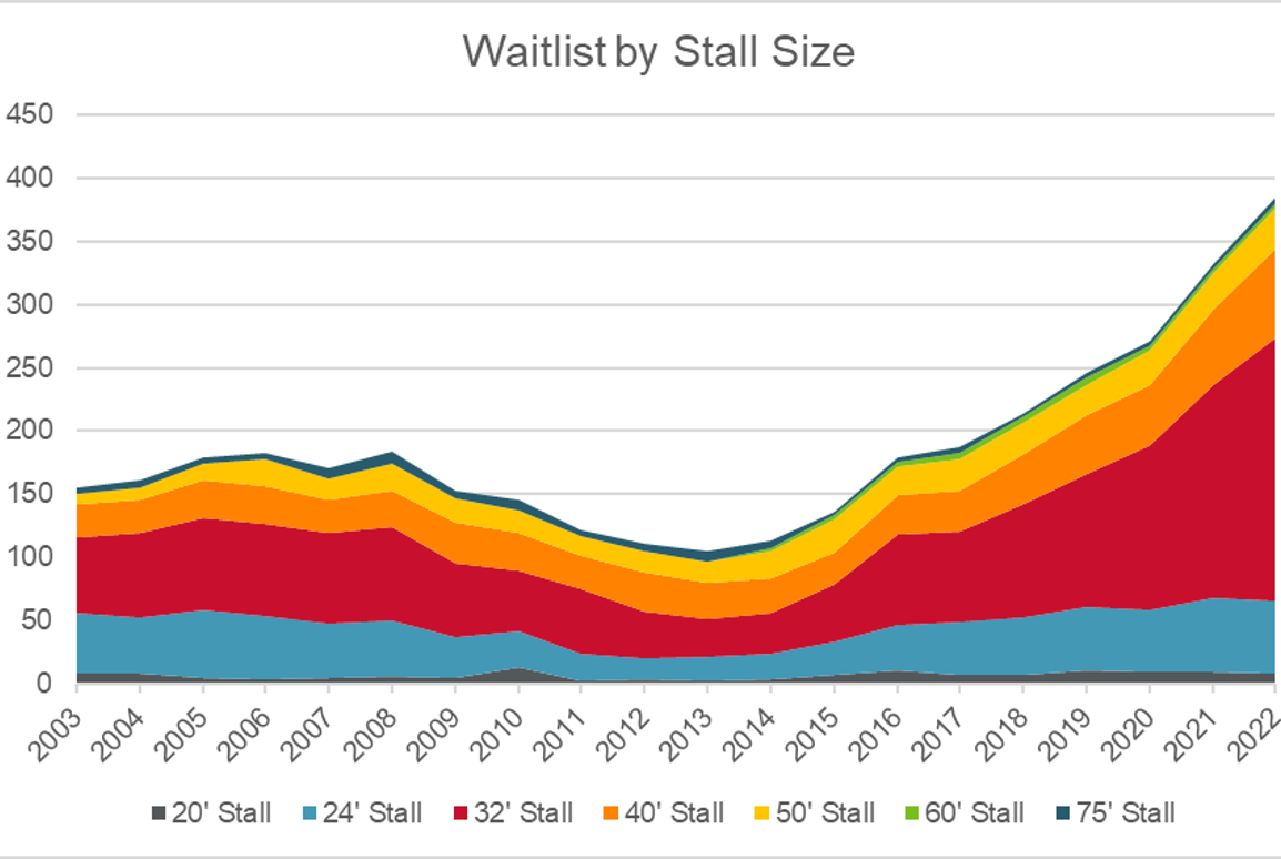
- Assessed potential future growth based on waitlist demand trends, vessels turned away for lack of moorage, and regional/state economics
- Hosted USACE-led focus groups targeting specific harbor user types to improve and confirm economics assumptions.
Why It Matters
- Provided the foundation for the study team to right-size the harbor designs ideas
- Developed 3 design fleets that were used to create Alternatives 1A/1B, 2, and 3
